


Geographic Information System and Information Visualization Capacity Building: Successful Polio Eradication and Current and Future Challenges in the COVID-19 Era for the World Health Organization's African Region
World Health Organization (WHO) Regional Office for Africa (Kipterer, Touray, Godwin, Cisse, Aimee, Busisiwe, Derrick, Henry, Modjirom, Ahmed); Bill & Melinda Gates Foundation (Seaman)
"The integration of polio transition processes involves the bringing together of various stakeholders and resources to ensure a smooth and effective transition. This includes integrating polio surveillance systems into existing disease surveillance networks, incorporating polio vaccinations into routine immunization programs, and merging the expertise and infrastructure developed for polio eradication with broader public health initiatives..."
Despite decades of effort, polio continues to impact individuals and communities worldwide, especially in low-income countries affected by conflict or geographic barriers to immunisation programmes. In Sub-Saharan Africa, with its limited access to geographic information system (GIS) infrastructure and inadequate technical and analytical skills, Global Polio Eradication Initiative (GPEI) activities are coordinated through the World Health Organization (WHO) Regional Office for Africa (AFRO) GIS Centre. This review describes the components of the WHO AFRO GIS and how the AFRO GIS Centre coordinated on-the-ground polio eradication efforts to help secure Africa's certification as wild poliovirus (WPV) free. It also examines current and prospective challenges in the COVID-19 era and strategies the GIS Centre is using to address these ongoing public health needs in Africa.
GIS is a computer system used to capture, store, verify, and display 3-dimensional location data - i.e., data related to positions on Earth's surface. In the public health sphere, GIS is used to integrate and track data collected for environmental and disease outbreak surveillance, track field activities such as vaccination campaigns, and provide essential information on the movement and activities of field personnel.
Proof of concept for the application of GIS software to polio eradication programmes was documented in multiple African nations prior to the WHO AFRO GIS Centre's establishment in 2017. To build on these successes, the AFRO GIS Centre was established to ensure proper national adoption of GIS, build the required capacity in relevant knowledge areas at all levels throughout Africa, and support regional and national interventions in surveillance, routine immunisation, supportive immunisation activities, information management, monitoring, and evaluation and accountability of teams and individuals at all levels.
To achieve these goals, the AFRO GIS Centre rolled out a series of train-the-trainer initiatives consisting of regional, in-person workshops intended to teach GIS focal points (national health ministry officials and data managers, as well as the WHO data management representative in each country) how to use GIS for field data collection, management, and visualisation, as well as how to deploy GIS resources locally. Initially, AFRO GIS Centre efforts were directed toward polio eradication in Africa. After WPV-free certification was achieved, AFRO GIS Centre initiatives were focused on improving African member states' ability to use AFRO GIS Centre resources to address cVDPV outbreaks, Ebola, COVID-19, and other emerging crises.
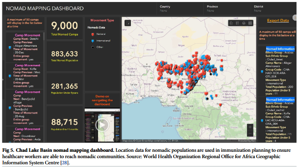
The AFRO GIS comprises a set of mobile device or cloud-based tools for geospatial data collection, analysis, and visualisation. As detailed in the article, using tools such as Auto-Visual Acute Flaccid Paralysis [AFP] Detection and Reporting, electronic surveillance, and Integrated Supportive Supervision, GIS personnel collect polio case numbers and locations, track field worker activities, follow the movements of nomadic populations vulnerable to polio and other diseases, and determine needs for further healthcare deployments. The system is location specific and operates in real time, enabling the AFRO GIS to promptly target its responses.
After the series of GIS capacity-building workshops held over the first 6 months of 2022, the GIS network consisted of over 120 GIS focal points across 45 of 47 countries in the WHO African region, and over 200 health ministry workers had been trained on GIS-related mobile health skills. In addition, 20 African nations (18 WHO AFRO member states) made their population and demographic data available on GeoPoDe (Geographic, Population, & Demographic Data), an open-source repository for geospatial reference data sets. The WHO AFRO GIS enables frontline workers to promptly alert health ministries of potential disease outbreaks based on real-time data from active AFP surveillance visits and environmental sampling.
After the WHO AFRO GIS Centre was established, use of GIS mobile applications in community-based surveillance activities and surveillance active cases helped close gaps in polio surveillance and immunisation in several high-risk areas, including communities in Burkina Faso, the Lake Chad region, Mali, and Niger. One of the most dramatic AFRO GIS Centre successes involved improving polio surveillance and immunisation coverage in the remote Lake Chad region. During the COVID-19 pandemic, WHO AFRO GIS Centre systems were repurposed for COVID-19 surveillance and contact tracing. Because health officials were already familiar with GIS for polio surveillance, minimal training was required for COVID-19 application.
Another effort underway is the development of a shared, centralised WHO AFRO geodatabase that will include information on health facilities, administrative boundaries, environmental and disease surveillance sites and data, and other GIS information in a centralizsed portal. For example, the WHO AFRO GIS is working with member states' ministries of health to create a consolidated health facility master list for AFRO. When WHO field staff conduct immunisations or investigate infectious disease cases reported at health facilities or traditional healer sites, they collect location data for those sites. The inclusion of traditional healers in the master list is an important component of polio disease surveillance because they provide healthcare to most Africans, especially in rural areas. When complete, the health facility master list will serve as a resource for WHO staff and their partners in each AFRO member state.
The article presents a series of recommendations for WHO member states and WHO to keep in mind going forward. Here are just a few examples:
WHO member states:
- Foster interministry collaboration to ensure sharing of information and resources, and develop comprehensive and all-inclusive digital-health strategies.
- Ensure health-system stakeholders and partners share outputs of their activities and are aware of and have access to GIS.
- Support interoperability, information sharing, and decentralised data management to ensure availability and accuracy of GIS to be used in emergencies.
WHO:
- Develop and foster mentorship programs to facilitate dissemination of GIS-related knowledge and resources.
- Provide guidance and documentation on GIS tools and systems.
- Develop platform for member states and partners to document and share experiences, success stories, and details of GIS-related national projects and innovative technologies.
In conclusion: "The WHO AFRO GIS Centre will continue to improve GPEI capacity in terms of trained personnel, and systems support and integration, with the goal of faster detection and response to polio and other disease outbreaks in the COVID-19 era."
PLoS ONE 19(8): e0307001. https://doi.org/10.1371/journal.pone.0307001. Image credit: World Health Organization Regional Office for Africa Geographic Information System Centre
- Log in to post comments