


Improving Immunisation Coverage and Equity through the Effective Use of Geospatial Technologies: A Landscape Analysis and Theory of Change
HealthEnabled
"In the context of the Covid-19 pandemic, the accelerated development of tools for data sharing and collaboration between remote locations using the common language of geography is more important than ever to advance the delivery of immunisation services."
Geospatial technologies, including global navigation satellite systems (GNSS), geographic information systems (GIS) and remote sensing, are tools for facilitating immunisation programme implementation through the visualisation and analytical power of maps, geospatial analysis, and modelling. This report provides an overview of lessons learned and recommendations for the use of geospatial data and technologies to improve immunisation coverage and equity in low- and middle-income countries (LMICs). It is the result of a collaborative effort on the part of Gavi, the Vaccine Alliance, and the United Nations Children's Fund (UNICEF) to evaluate and invest in the potential for digital innovations to improve global immunisation programmes.
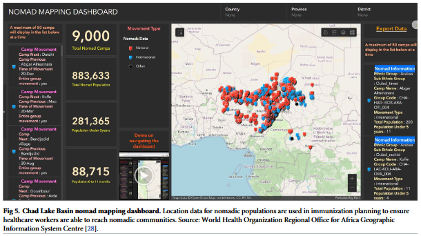
The HealthEnabled researchers conducted a rapid review of published studies, research, and literature to examine the use of geospatial technologies for immunisation programming in LMICs; 38 publications were included. Overall, the studies demonstrate how the visualisation of geospatial data, spatial analysis, and geospatial modelling can help service delivery teams identify zero-dose children (children who have never been immunised) and improve service delivery to achieve equity in vaccine coverage. For example, programmes that have implemented real-time tracking of vaccinator teams see improvements in attendance at immunisation campaigns and the ability to ensure that all assigned catchment areas are covered, resulting in a reduced number of missed settlements.
Based on the review and on key informant interviews conducted as part of the landscape analysis, the report identifies 8 use cases where geospatial technologies have the greatest potential to shape immunisation outcomes: health system mapping, population estimation/spatial distribution, microplanning, disease surveillance, vaccinator tracking, campaign monitoring, geographic accessibility modelling, and vaccination coverage modelling. For each use case, the report outlines how technology can improve immunisation outcomes, what elements are needed, the main challenges, and the evidence/resource base. As noted here: "The most revolutionary application of geospatial data and technologies in immunisation planning will come from a change in how managers think about maps. Many stakeholders still think of a map as a paper-based resource, a static representation of a single point in time. The power of geospatial technology comes when multiple layers of data are combined with the element of time to transform a paper map into a whole new category of decision-making tools."
In order to understand how the use cases come together to geo-enable programmes for immunisation delivery, the report examines in-country implementation at national and sub-national levels, drawing on experiences in Nigeria, Myanmar, and Cameroon. Lessons learned in these and other contexts are outlined, such as the the fact that the focus of any initiative to use geospatial technologies must be on the people, underlying systems, and programme priorities, not on the technology itself. For instance, in systems where immunisation rates have been artificially inflated to maintain performance targets, a mobility tracking system may seem like a punishment or may reveal more information than staff are ready to face. Such lessons and challenges "highlight the need for a clear enabling environment that covers aspects such as governance and leadership, policies, data specifications and protocols, technical capacities and resources to support the sustainable use of geography as a unifying dimension in a national health information system (HIS)."
These foundations form the basis for a theory of change for the use of geospatial technologies for immunisation programming, found on page 33 of the report.
In conclusion, the following recommendations are offered:
- "Prioritise building foundations for a sustainable geo-enabled immunisation information system, including national governance, policies, resource allocation, capacity building and proper data management practices;
- Invest in and promote the strengthening of in-country technical expertise in the management and use of geospatial data and technologies through collaboration with regional partners, local universities and research centres, integrated training and local capacity building for all donor-funded applications;
- Promote the use of the appropriate geospatial technologies and tool platforms, including open-source solutions, for the management, visualization, analysis, modelling and sharing of geospatial data within and across sectors in support of immunisation programmes;
- Address data privacy and security issues when using geospatial data and technologies in-line with global best practices and national policies;
- Promote the use of geospatial data and technologies and the products they generate as advocacy tools for decision-makers to see the potential of a geo-enabled immunisation information system;
- When assessing the impact of geospatial technologies on immunisation programmes, adopt an impact framework not limited to coverage outcomes but rather a comprehensive analysis of the variety of pathways to change, including accountability, accessibility, equity, cost-benefit/cost-effectiveness and efficiency;
- Document and share program experiences and lessons learned to promote the expanded use of geospatial data and technologies for immunisation programming."
Gavi website, January 12 2022. Image credit: Frank Salet
- Log in to post comments