


Every Child on the Map: A Theory of Change Framework for Improving Childhood Immunization Coverage and Equity Using Geospatial Data and Technologies
HealthEnabled (Chaney, Mechael); United Nations Children's Fund (UNICEF), Juba (Thu); UNICEF, New York (Diallo); GAVI, the Vaccine Alliance (Gachen)
"In order to provide life-saving services to children who default on the vaccination schedule and 'zero-dose' children who have never received a vaccine, new geo-enabled approaches to planning and delivering services are needed to expand the reach of effective vaccination for all children."
Immunisation programmes in low- and middle-income countries (LMICs) are beginning to harness digital maps to display and analyse complex information. The effective use of geospatial data can show programme managers which locations have not received adequate immunisation services, inform vaccination delivery strategies to optimise coverage and equity, and improve monitoring of immunisation programmes. This article presents a theory of change for the use of geospatial technologies for immunisation programming that was developed as part of a collaboration between GAVI and UNICEF.
The theory of change is the result of: a review of the state of the evidence and literature; consultation with implementers, donors, and immunisation and geospatial technology experts; and a review of country-level implementation experiences. It represents a thought process aimed at understanding the underlying sequence of events that can contribute to sustained and effective improvements and should be considered a roadmap that is subject to change, improvements, and fine-tuning as country-level experiences bring insights from real-world challenges.

The framework illustrates how the effective use of geospatial data and technologies can help immunisation programmes realise improvements by:
- Increasing the number of children immunised through improved target-setting: Microplans developed with geospatial technologies and data can be a cost-effective way to identify settlements missed with traditional microplanning activities that rely on hand-drawn paper maps. With more accurate and reliable information about the locations, characteristics, and number of settlements within their catchment area, managers can plan and prioritise their activities to vaccinate more children and monitor progress both from the local and central levels.
- Optimising immunisation resource distribution and location of services: By enabling identification of chronically missed settlements and locations with the highest number of zero-dose and under-immunised children, tools and approaches that use geospatial technologies can help immunisation managers make more targeted decisions for where and how to focus activities and resources.
- Improving the quality, timeliness, and perception of immunisation services, with equity in coverage between communities: Measuring and monitoring geographic and socioeconomic pockets of inequality is the first step toward promoting equality in coverage. Mobile technologies and cellular networks provide opportunities to improve data collection, transfer, analysis, and use. The transparent sharing of data can promote a common understanding of expectations and challenges between vaccinators and supervisors.
GAVI and UNICEF suggest that, through these direct effects on service delivery, geospatial data and technologies can contribute to the strengthening of the overall health system by ensuring equity in immunisation coverage.
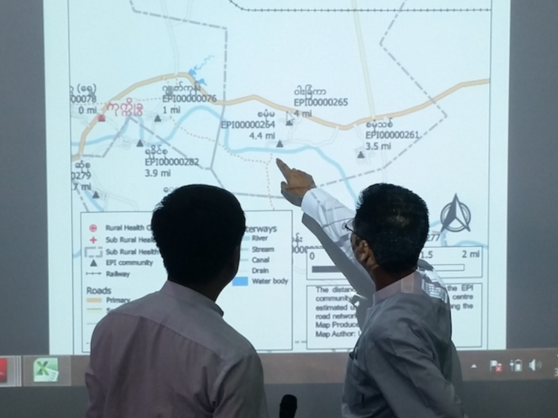
The paper provides a case study of how Myanmar's process of integrating geospatial data and technology for immunisation microplanning validates the progression of incremental steps outlined in the theory of change. As noted here, health workers were fully engaged in the process by reviewing the online and printed maps that were produced and making necessary adjustments to their immunisation microplans based on available transportation routes, distances, and geographic features, in coordination with their supervisors. Reportedly, the transparency and sharing of microplans and maps enabled supervisors to provide better support to health workers and encouraged accountability at all levels.
One lesson from Myanmar's experience is the importance of the enabling environment and foundations in the theory of change. The high-level commitment to transition to a geo-enabled national health information system in the Department of Public Health in Myanmar, with support and technical guidance from the World Health Organization (WHO), GAVI, UNICEF, and the Health GeoLab Collaborative (a center of excellence for the Asia-Pacific region), "laid a strong foundation of advocacy, governance, policies, and capacity for the management and use of geospatial data and technologies in the broader health sector".
In conclusion: "The theory of change presented here may serve as a guide for country program managers, implementers, donors, and other stakeholders to better understand how geospatial tools can support immunization programs and facilitate integrated service planning and equitable delivery through the unifying role of geography and geospatial data."
Journal of Medical Internet Research (JMIR) 2021;23(8):e29759) doi: 10.2196/29759. Image credit: JMIR
- Log in to post comments